Taou Blanc


Edited by:
Giancarlo Beretta
Updated at: 25/08/2025
Access
Lasciare l'autostrada allo svincolo di Aosta Ovest e proseguire fino all’innesto con la strada statale . Svoltare a sinistra al semaforo e procedere in direzione Courmayeur. Superati gli abitati di Saint-Pierre e Villeneuve, dopo 6,6 chilometri imboccare sulla destra la strada regionale della Valsavarenche, che attraversa rapidamente Introd e, dopo altri 4,7 chilometri, si dirama diventando la strada regionale della Valle di Rhêmes. Risalire la vallata per 14,9 chilometri, oltrepassando Rhêmes-Saint-Georges, fino a raggiungere Bruil, capoluogo del comune di Rhêmes-Notre-Dame. La strada si inoltra nel fondovalle, supera il piccolo villaggio di Pellaud e prosegue ancora per qualche minuto, fino a raggiungere l’ampio parcheggio 🅿️ a pagamento di Thumel, situato all’inizio dei principali sentieri della zona.
La tariffa è di 50 centesimi per la prima ora e di 15 centesimi per ogni ora successiva.
Distanza e tempo di percorrenza
🕒 Tempo di percorrenza: 39 minuti
📏 Distanza: 29,6 km
Navigazione GPS
📍 Come arrivare con Google Maps
📍 Come arrivare con Apple Maps
ℹ️ Nota importante
Le indicazioni fornite sono state verificate alla data del rilievo dell’itinerario. Prima della partenza, è consigliabile verificare eventuali variazioni del percorso. Per ottenere indicazioni aggiornate e dettagliate, si consiglia l’uso di Google Maps o Apple Maps.
Introduction
This excursion, with a considerable difference in height and length, reaches a summit, also at a considerable altitude, on an evident path and track, without facing any great technical difficulties; in fact, the first rocky prominence immediately after the pass can easily be avoided on the left, while the terminal rocks of the summit are well stepped and solid. The trail disappears when you reach the morainic terrain, but there are visible cairns indicating the route as far as below the Leynir pass; care must be taken, especially in the case of poor visibility, when you get to one of the morainic ridges to be climbed over not to be misled by a faint trail, which has some old yellow paint stripes on the stones, that follows the crest of the moraine because it is lost a little further on near the rocks. To describe the panorama from the summit, a page would not be enough to list all the mountains visible, but on a clear day the 360° view is truly exceptional.
Description
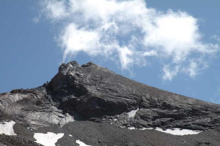
From the car park, continue along the tarmac road as far as the marker posts towards its end and turn left, descending briefly onto a dirt track that passes by the village of Thumel and approaches the stream by crossing it over a wooden bridge. We skirt a large smooth rock and take the obvious path that heads into the forest, crossing two forks at which we keep to the right at the first, while at the second we continue to the left on a flat track. Entering the forest, the slope increases noticeably and the path, ascending it with steep hairpin bends, quickly gains height and approaches the stream that descends next to an old landslide, arriving at a small plateau; now the track heads towards a stony area, after which, on the nearby opposite slope, a stone Park building can be seen. The progression becomes easier by following the well-trodden path that continues along the bottom of the small valley, crossing a stream and then, having passed a bridge, moves to the opposite side making a semicircle to the left, arriving shortly at the Upper Vaudalettaz P.N.G. hut (2480 m). The track climbs to the right of the building, reascending the short buttress, and continues into the Vaudalettaz valley, rising up the grassy slope of the mountain to the orographic right, at the end of which we come to an area of stones and grass, where the track gets a little lost for short stretches, which we climb up laboriously. The terrain suddenly changes physiognomy, becoming only stony, with the track, well signposted by small stone cairns, creeping into the small morainic depressions, reaching an obvious large cairn higher up. The slope decreases and the trail continues on morainic ground past an obvious yellow rock (2917m) beyond which the trail disappears completely to the Leynir pass. Cross the moraine area on the level, heading towards some low smooth rocks where you can see some small stone cairns; follow them and continue past a large boulder with a yellow arrow near a small lake and approach the tongue of the small Vaudalettaz glacier that descends from the Leynir pass. If one arrives early in the morning, when the snow is hard, crampons may be useful for climbing comfortably below the vertical of the pass, otherwise one continues on its left-hand edge, climbing laboriously among shifting stones and wet crushed earth, aiming at an obvious smooth rock that is a little reddish, which one passes carefully. Beyond this, you will soon reach the Leynir pass (3084m), where there is a stone marker. From here, towards the east, a faint track begins, well signposted by small stone markers up to the summit, which surrounds a rocky area on the left and, with a few bends, climbs up towards some smooth rocks that are carefully overcome to reach a fork where there are two alternatives to continue: the first continues to the left on the stone track, and the second continues briefly to the right, arriving at some small rocks that can be conquered directly with an easy climb up the short notch. Above these, take the track that climbs up the wide ridge, arriving, with a few zig-zags, at the base of the summit rocks, which are easily overcome to reach the cairn on the small peak.
.We have been there
Edited by:
Giancarlo Beretta
Taou Blanc
Sino al Col du Leynir ho già detto. Oltre questo punto la traccia è vsibile e accompagnata da ometti di pietre. Bello, facile ed anche divertente risalire le poche roccette iniziali per rompere la monotonia della camminata, mentre in discesa conviene deviare sulla destra per la traccia segnata. Sull'itinerario non vi è più alcuna traccia di neve e sotto la cima si può scegliere se raggiungerla direttamente o fare qualche riposante zig-zag prima del "rampichino" finale. In cima sotto i sassi dell'ometto si trova, custodito in un bel contenitore d'acciaio, il quaderno di vetta sul quale purtroppo non vi è più un seppur piccolo spazio in bianco dove mettere la propria firma: non so chi sia preposto a farlo ma bisognerebbe sostituirlo al più presto. Inoltre dalla piccola cima posta al termine della breve cresta che si dirige a sud si ha una migliore visuale sulla zona di Pont di Valsavarenche, sul sentiero che inizia ad attraversare il pianoro del Nivolet e sul sottostante laghetto situato sul pianoro di Plan Borgnoz.