Aiguille Blanche de Peuterey

Edited by:
Massimo Martini
Access
Head to Courmayeur and make your way up the Val Veny to the village of Fréney, where the path to the Monzino Refuge begins: 2h30’, including a secured section over the rocky outcrops below theAiguille du Châtelet. From the refuge, any ascent of La Blanche requires crossing heavily crevassed glaciers, either on the Fréney or Brenva sides. Glacial changes over recent decades have made these approaches longer and more exposed to falling rocks and ice. Reach the Craveri Bivouac from the Monzino Refuge in 5h (D), via the Colle dell’Innominata, the Fréney Glacier and the Schneider ledges, or from the summit of the Aiguille Noire de Peuterey along the full ridge. For the descent, follow the summit ridge to Punta Jones, abseil down to Colle di Peuterey and return via the Rochers Gruber onto the Fréney Glacier.
Ascent routes
Standard route – from Craveri Bivouac (3,490m) – south-east ridge – D+ –
Traverses
Peuterey Ridge – from the Monzino Hut (2,580m) to Mont Blanc de Courmayeur, via theAiguille Blanche, the Peuterey Pass and the Grand Pilier d’Angle - Elevation gain
Full Peuterey Ridge – from Lorenzo Borelli Bivouac - Carla Pivano (2,325 m) to Mont Blanc de Courmayeur, via the Aiguille Noire de Peuterey, the Dames Anglaises, theAiguille Blanche and the Grand Pilier d’Angle
Introduction
The Aiguille Blanche de Peuterey (4,112 m) is a peak in the Mont Blanc massif, in the municipality of Courmayeur, above the Val Veny. It lies on the Peuterey ridge, the ridge that, from theAiguille Noire to Mont Blanc de Courmayeur via the Dames Anglaises, the Col de Peuterey and the Grand Pilier d’Angle, and separates the Brenva Glacier to the east from the Fréney Glacier to the west. The summit is a snow-covered ridge with three peaks of almost equal height. Every route involves long approaches across crevassed glaciers and sections of unstable rock, and the normal route is considered the most difficult of all the four-thousand-metre peaks in the Alps. The first ascent took place in 1885, three years after the death of Francis Maitland Balfour during an attempt from the Fréney side.
Description
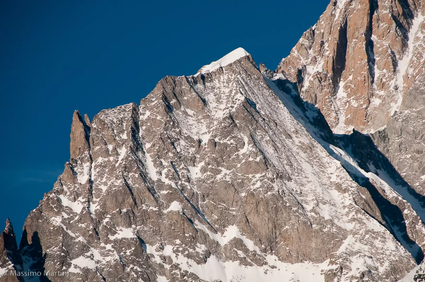
The summit ridge, running from north-west to south-east, features three peaks: Punta Güssfeldt (4,112 m), the central and highest peak; Punta Seymour King (4,107 m) to the south-east; and Punta Jones (4,104 m) to the north-west. The peaks are named after Paul Güssfeldt, Henry Seymour King and Humphrey Owen Jones. To the south, the ridge descends to the Brèche Nord des Dames Anglaises, where the Craveri Bivouac is situated, and continues via the spires of the Dames Anglaises to theAiguille Noire de Peuterey. To the north, the descents from Punta Jones lead to the Colle di Peuterey, from where the ridge ascends to the Grand Pilier d’Angle and Mont Blanc de Courmayeur. On the south-western slope lies the rocky secondary summit of Pic Gugliermina. The east face drops down to the Brenva Glacier and is fully visible from Punta Helbronner and the Torino Hut; the western slope overlooks the upper Fréney basin. In the SOIUSA classification, the peak belongs to the subgroup of the Italian Spurs of Mont Blanc, within the Mont Blanc Group (Mont Blanc Alps, Graian Alps).
The mountain is composed of granite from the Mont Blanc massif. However, ascent accounts – from the first in 1885 to more recent ones – describe weathered and unstable rock on the summit ridge and the access ledges, with frequent rockfalls on both glacial slopes.
The name contrasts the Aiguille Blanche, crowned by a snow cap, with the Aiguille Noire, a rocky spire. The name ‘Peuterey’ is shared with the ridge and with the locality of the same name at the entrance to Val Veny; in nineteenth-century mountaineering sources, the spelling ‘Peuteret’ also appears.
Francis Maitland Balfour died in 1882 alongside his guide Johann Petrus during an ascent attempt from the Fréney side; Emile Rey led the team that recovered their bodies. On 30 July 1885, Henry Seymour King set off from Courmayeur with the guides Ambros Supersaxo and Aloys Anthamatten, and with Emile Rey, who had joined the rope party the previous evening. After bivouacking on the ridge between the Brouillard and Fréney glaciers, the party descended into the upper Fréney cirque, reached the pass towards the Brenva and, following the ridge, reached the snow-covered summit at 2.00 pm on 31 July. In August 1893, Paul Güssfeldt, accompanied by Emile Rey, Christian Klucker and César Ollier, ascended the ridge via a couloir on the Brenva side and followed it past theAiguille Blanche and the Grand Pilier d’Angle to Mont Blanc de Courmayeur: this was the first ascent of the Peuterey ridge, repeated a week later by Klucker with John Percy Farrar. In 1909, Humphrey Owen Jones, guided by the Courmayeur guide Laurent Croux, climbed the south-west spur of the peak that bears his name. From 28 to 31 July 1934, Adolf Göttner, Ludwig Schmaderer and Ferdinand Krobath made the first traverse of the entire ridge, from the Aiguille Noire to Mont Blanc. In 1938, Gabriele Boccalatte and Giusto Gervasutti opened the route bearing their names on Pic Gugliermina. On 7 March 2025, François Cazzanelli and Giuseppe Vidoni opened the ‘Bianco Invisibile’ route on the east face, an 800-metre mixed route ending at the Brèche, at 3,900 metres.
In the account read at the Alpine Club in 1886, King recounts that, upon reaching the summit, the party hoisted an Italian flag on an alpenstock carried up there by the guides. The ascent had been observed from the valley floor: their return to Courmayeur was greeted with cannon fire, and King commented on the feat with the pun “Val Veni, vidi, vici”.
Support
Monzino Refuge
Craveri Bivouac
Information
Elevation: 4,112 m
Alternative name: Aiguille Blanche de Peuteret (historical spelling)
Mountain range: Italian spurs of Mont Blanc (SOIUSA sub-group, Mont Blanc massif, Mont Blanc Alps)
First ascent: 31 July 1885 – Henry Seymour King with the guides Emile Rey, Ambros Supersaxo and Aloys Anthamatten
Towns: Courmayeur
Valleys: Val Veny
Climbing difficulty: D+ (standard route via the south-east ridge)
Glaciers present: yes, the Brenva and Fréney glaciers